


Romanian maps under ‘Lambert-Cholesky’ (1916-1959) projection system
de Vasile Crăciunescu, Ioan Rus, Ștefan Constantinescu, Ionuț Ovejanu, Zsombor Bartos-Elekes
This campaign is a part of the eHarta collaborative project. For more details please visit the dedicated page. The publishing of these maps was possible with the help of the following community members (listed here in alphabetical order): Paul Alexandrov, Paul Androo-Gherghelas, Claudia Blagu, Razvan Bogza, Marius Budileanu, Rares Buian, Bogdan Candrea, Sorin Constantin, Adrian Covasnianu, Ionut Cristea, Matei Domnita, Florin Filip, Mihai Florea, Cristian Flueraru, Dragos Gaitanaru, Dana Grad, Bogdan Grecescu, Ioan-Raducu Grigoras, Codrina Maria Ilie, Robert Ille, Iulian Iordache, Florin Iosub, Marius Jigmond, Antal Kosza, Botond Mar, Constantin Petre Marinca, Cristina Mavriche, Adrian Muresan, Ion Nedelcu, Mihai Nita, Claudiu Onea, Ionel Popa, Simona Prodan, Cezar Radu-Buterez, Ionut Rus, Ciprian Samoila, Bogdan Sandric, Ionut Sandric, Laura Satmari, Andreea Diana Sava, Vasile Cristian Stan, Mihaela Stoiov, Dan Teodor, Mihai Terente, Corina Tudorache.
Gnoseology context
Before the 1918 Union, the Romanian territories were subject of several dominations, for which reason the cartographic data base for each Romanian province was different from an area to another. Starting from the second half of the 19th century, Valachia, Moldavia and Dobrogea field mapping was made, implicitly cartographic representations, different as structure. The projection systems used, the chosen ellipsoid, the nomenclature and the distribution of the map pages were not uniform. For example, the Bessel ellipsoid and the Cassini cylindrical projection were used especially to the eastern side of the Zimnicea central meridian (23 degree east from Paris), while to its western side the Bonne conic equivalent projection was used, as defined on the Clarke ellipsoid (Năstase, 1975). In the other Romanian provinces, such as Transylvania, Romanian Banat, Bessarabia (Moldavia Republic) and Southern Bucovina, the major part of the cartographic products (surface contour maps) were made as polyhedral projections with Bessel ellipsoid.
During the World War I, when artillery was a redoubtable weapon a necessary idea was born to articulate an unitary cartographic projection concerning the entire Romanian territory, which should respond to the principle of conformity. Between 1916-1917, pursuant to the above argumented measure, a new datum/location surface, a new projection system and a new nomenclature were introduced. The Lambert projection system was used as modified by the French land surveyor, the mathematician and officer Andre Louis Cholesky. He was born in 1875 in Mont Guyon and passed away on the battle field in Northern France in the month of August 1918. During September 1916 up to February 1918, following the Franco-Romanian military convention, he was a Commander of the Geographic Department of the Romanian Army (Brezinsky and Cholesky, 1996). The calculations for transforming from the various projections (as previously mentioned), into the Lambert-Cholesky projection, were made by the Romanian officers (Osaci-Costache, 2000 pg. 138).
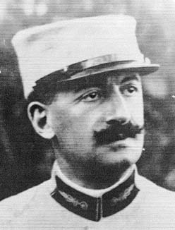
Andre Louis Cholesky
Maps projection
The datum/location surface used by the Lambert-Cholensky projection was defined on the Clarke ellipsoid 1880. We have no data concerning the used datum. Employing Clifford’s and Mugnier’s (2001 page 547) data, we may state that the geometric elements of the ellipse used were: major semi-axis (a): 6378249,2 m; minor semi-axis (b): 6356515,0 m. These values differ only by 10 cm compared to the Clarke ellipsoid 1880, a difference which we may consider as a round-off error. We have no data on the actual position of the co-ordinates system centre. From the location surface it was arrived at the plane surface by using the conic conform projection of Lambert. The projection central meridian was located at 2 centesimal degrees western side of the meridian of the Military Astronomic Observatory in Bucharest (24°18'44,99" eastern longitude, respectively 45°02'29,216" northern latitude). The size of the longitudinal deformation was reduced on the central parallel (l = 0,99844674), in this manner arriving in the situation where the longitudinal reducing on the central parallel and the longitudinal increasing on the parallel placed on the eastern border of the territory intended to be reciprocal one to each other (Cliford and Mungier, 2001 pg. 547). In this manner we are able to determine the projection central point in Valea Oltului in the closed vicinity of Stolniceni locality in Vâlcea county. The co-ordinates system was placed so that the crossing point of the 450 and the central meridian should observe the relation x = y = 500km. The Cartesian coordinate of the projection central point is x = 500000m, respectively y = 504599,11m (Cliford and Mungier, 2001).
Scale and nomenclature system
The basic map, called „Plan Director de Tragere” was drafted under 1:20000 scale in 2118 drawings, covering all the Romanian territory. Under graphical aspect, such map sheet had a 75 cm width (the equivalent of 15 km of land), respectively 50 cm height (the equivalent of 10 km of land). Usually, at the upper part of the map, frequently to the left side, less frequently to the right side, the drawings nomenclature appeared, made following the principle: the first two letter meant the columns number divided by 15 and the last two digits represented the row number. So, the drawing whose south-west corner had the Cartesian co-ordinate of 450,000 m Eastings and 20,000 m Northings would have received the codification 3020.
Another series of maps of the same family was made under the 1:100000 scale, representing 102 drawings, covering the entire national territory. The drawings under the 1:100000 scale had the same size as the basis map, therefore they were covering a surface 25 times larger. The drawing nomenclature corresponded to the drawing under the 1:20000 scale in the south-west corner. The drawings under the 1:200000 scale were executed equally, with the same graphic dimension.

Mapsheets index
Basic material and content of the map
The maps under Lambert-Cholensky projection, especially those ones made in the first period, were not the result of some new measurements, but they proceeded from previous sources (Romanian, Austrian, Russian), graphically transposed. Since 1924, a major part of the data in these maps was updated on the grounds of the aerial photograms. Subsequent to the Agricultural Reform in 1921, the maps toponimy was modified, numerous Romanian denominations being added (Năstase, 1875 page 87).
On the maps under the 1:20000 scale, the relief was represented as elevation curves with an equidistance of 20 m, and on the maps under the 1:100000 scale, the equidistance was of 100 m. In order to represent the relief, the 1:200000 Variant employed the hachure method. The toponyms are usually written in Romanian language, while in Transylvania and especially in the transfrontalier areas, mixed toponyms are noticed. Colours used in the basic map printing were brown for the relief and black for the remaining representations. On some maps a third colour appears (green for vegetation).
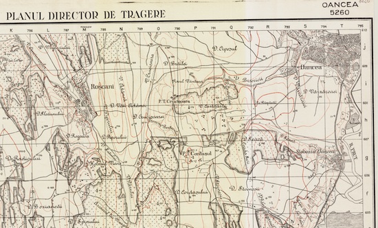
Exemple: fragment from the mapsheet no. 5260
New editions of the maps. Importance and methodology of studying them
Editing, printing and spreading of the same covered many years, up to 1959. Even at the beginning of the fourth decade, the projection changing have been decided (Hayford ellipsoid and the secant stereographic projection), a minor part of 5% of such maps were transposed in the new system (Năstase 1975, page 87). During the `50, the maps contents and accuracy gradually begin not to correspond anymore to the military topographic exigencies. By this reason, and due to the fact that the maps under Lambert-Cholensky projection were not accordable to the Gauss-Kruger maps, as used by the soviet space, a decision to implement a new projection system for the Romanian space has been taken. This system is founded on large measurements campaigns, starting in 1951 and their results have been materialised into the new Gauss-Kruger projection maps. In parallel, between 1954 up to 1959, the most recent drawings under Lambert-Cholensky projection was edited and printed, bearing numerous toponymy corrections (Osaci-Costache, 2000).
The significance of the Lambert-Cholensky projection maps consists in the fact that they represent the first cartographic product referring to the entire Romania, under an unique projection system, and having an unitary legend. Furthermore, these ones are the maps achieved at the highest scale up to that moment. In the mean time, they represent a public and not classified cartographic product, as well.
Maps scanning, processing, documentation, georeference and publishing
The conversion of the maps from the original support (paper or linen) to digital, geo-aware, format represented an important challenge. Most of the maps (1700+) were obtained from the archives of the Faculty of Geography – University of Bucharest and the Faculty of Geography – University Babes Bolyai. Their scanning was made at the Cluj University, using a reel scanner, A0 paper size, thus obtaining *.tif formats having a 300 dpi resolution. Later on, with help from Bogdan Șandric (Institute for Cultural Memory) and Mihai Florea (National Museum of Romanian History), the map collection was enriched with 70+ additional maps.
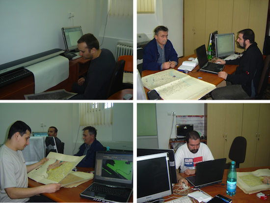
“At scanning”
Map sheets documentation and georeference was done with the help of the community through the eHarta project. We thank everyone.
Map sheets processing (georeference, clip, optimization, etc.) was done automatically using GDAL library. We rely on GeoServer + GeoWebCache to create standard geospatial web services (WMS, WMTS/WMS-C/TMS, KML).
Download
The maps, georeferenced in Stereo70 coordinate system, can be downloaded individually in format GeoTiff format. A dedicated application was created for map selection and download. Web access to the maps is possible through standard geospatial services (WMS, WMS-C), geo-spatial.org webmapping application, or Google Earth.
